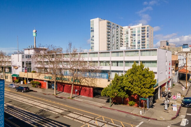
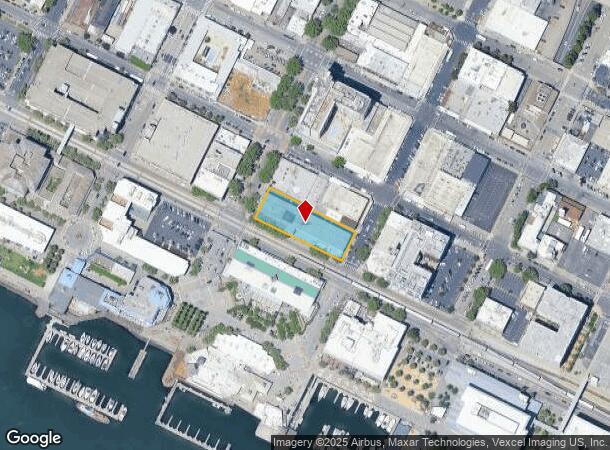
Property Record
444 Embarcadero W, Oakland, CA 94607

NEARBY LISTINGS FOR SALE OR LEASE
Property Detail
444 Embarcadero W
Oakland-Fremont-Berkeley, CA
Kellerbergers Map/Oakland
001-0141-017-02
LOT: 00002 BLK: 0017 AR: 0001 PAGE: 0141
Motel
Alameda
X
California
06001C0067H
1-4
2024
0.70 AC
2025
Oakland/Berkeley/Hayward
983200
East Bay/Oakland
61,217 SF
DEMOGRAPHICS near 444 Embarcadero W
1 mile
3 mile
5 mile
2024 Total Population
29,958
239,143
462,400
2029 Population
29,816
233,436
449,347
Pop Growth 2024-2029
(0.47%)
(2.39%)
(2.82%)
Average Age
43
41
41
2024 Total Households
14,985
102,941
187,961
HH Growth 2024-2029
(0.67%)
(2.42%)
(2.88%)
Median Household Inc
$68,182
$88,647
$96,415
Avg Household Size
1.90
2.10
2.30
2024 Avg HH Vehicles
1.00
1.00
1.00
Median Home Value
$849,106
$946,007
$1,020,042
Median Year Built
1989
1960
1954
Nearby Places
Map Layers
Map Styles
 Street
 Aerial
Transit
 Traffic
 Biking
Places
Listings with unknown addresses are not visible on the map
- Restaurants
- Banks
- Shops
- Fitness
- Groceries
PUBLIC TRANSPORTATION
COMMUTER RAIL
Drive
Walk
Distance
1 min
5 min
0.3 mi
Drive
Walk
Distance
11 min
5.1 mi
AIRPORT
Metro Oakland International
Drive
Walk
Distance
Metro Oakland International
14 min
9.2 mi
San Francisco International
Drive
Walk
Distance
San Francisco International
37 min
23.4 mi
Freight Ports
Port of Oakland
Drive
Walk
Distance
Port of Oakland
1 min
0.3 mi
SALE & LEASE HISTORY
LISTING DATE
SALE/LEASE

Jun 18, 2025
For Sale
Nearby Properties
Address
Land Use
TOTAL SIZE
Lot Size
Zoning
Address
Land Use
TOTAL SIZE
Lot Size
Zoning
409,266 SF
1.76 AC
Address
Land Use
TOTAL SIZE
Lot Size
Zoning
1,028,501 SF
2.74 AC
Address
Land Use
TOTAL SIZE
Lot Size
Zoning
652,524 SF
1.38 AC
Address
Land Use
TOTAL SIZE
Lot Size
Zoning
617,980 SF
1.08 AC
Address
Land Use
TOTAL SIZE
Lot Size
Zoning
568,722 SF
0.99 AC
Address
Land Use
TOTAL SIZE
Lot Size
Zoning
767,791 SF
1.38 AC
Address
Land Use
TOTAL SIZE
Lot Size
Zoning
373,594 SF
16.16 AC
Address
Land Use
TOTAL SIZE
Lot Size
Zoning
488,781 SF
0.63 AC
Address
Land Use
TOTAL SIZE
Lot Size
Zoning
490,000 SF
1.44 AC
Address
Land Use
TOTAL SIZE
Lot Size
Zoning
432,352 SF
Address
Land Use
TOTAL SIZE
Lot Size
Zoning
525,866 SF
1.38 AC
Address
Land Use
TOTAL SIZE
Lot Size
Zoning
501,460 SF
1.18 AC
Address
Land Use
TOTAL SIZE
Lot Size
Zoning
Address
Land Use
TOTAL SIZE
Lot Size
Zoning
546,164 SF
6.02 AC
Address
Land Use
TOTAL SIZE
Lot Size
Zoning
328,427 SF
0.52 AC
Address
Land Use
TOTAL SIZE
Lot Size
Zoning
423,577 SF
1.04 AC
Address
Land Use
TOTAL SIZE
Lot Size
Zoning
Address
Land Use
TOTAL SIZE
Lot Size
Zoning
184,139 SF
0.52 AC
Address
Land Use
TOTAL SIZE
Lot Size
Zoning
405,462 SF
11.67 AC
Address
Land Use
TOTAL SIZE
Lot Size
Zoning
621,432 SF
1.31 AC
C
Address
Land Use
TOTAL SIZE
Lot Size
Zoning
288,796 SF
0.52 AC
Address
Land Use
TOTAL SIZE
Lot Size
Zoning
2.05 AC
Address
Land Use
TOTAL SIZE
Lot Size
Zoning
371,504 SF
4.08 AC
Address
Land Use
TOTAL SIZE
Lot Size
Zoning
788,983 SF
1.63 AC
Address
Land Use
TOTAL SIZE
Lot Size
Zoning
0.73 AC
Address
Land Use
TOTAL SIZE
Lot Size
Zoning
703,758 SF
3.44 AC
Address
Land Use
TOTAL SIZE
Lot Size
Zoning
371,322 SF
1.62 AC
Address
Land Use
TOTAL SIZE
Lot Size
Zoning
350,741 SF
1.08 AC
Address
Land Use
TOTAL SIZE
Lot Size
Zoning
344,273 SF
0.51 AC
Address
Land Use
TOTAL SIZE
Lot Size
Zoning
273,623 SF
1.44 AC
The World's #1 Commercial Real Estate Marketplace
Connect with us
© 2026 CoStar Group
The information above has been obtained from sources believed reliable. While we do not doubt its accuracy we have not verified it and make no guarantee, warranty or representation about it. It is your responsibility to independently confirm its accuracy and completeness. Any projections, opinions, assumptions, or estimates used are for example only and do not represent the current or future performance of the property. The value of this transaction to you depends on tax and other factors which should be evaluated by your tax, financial, and legal advisors. You and your advisors should conduct a careful, independent investigation of the property to determine to your satisfaction the suitability of the property for your needs.